
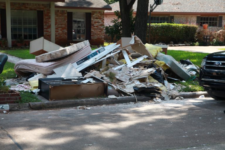
In 2017, Hurricanes Harvey, Irma and Maria were reminders of how vulnerable communities can be to flooding and natural hazards. Strong winds, torrential rains and storm surge caused severe damage that blocked roads and inundated entire communities. If structures in these areas are “substantially damaged,” local governments participating in the National Flood Insurance Program (NFIP) must ensure their residents improve their properties to higher standards. Unfortunately, it may not be the first time many of these homes experienced damage, which begs the question: How can FEMA best assist local governments to protect properties and keep residents out of harm’s way?

To reduce the risks of future flooding, communities participating in the NFIP are required to use the “substantial damage” or “50 percent rule,” which states that structures whose repair or remodeling costs exceed half of their pre-damage or pre-remodeled structure market value must be elevated or removed from the Special Flood Hazard Areas (SFHA). For decades, community officials nationwide have struggled with the implementation and enforcement of this rule, especially after disasters. The process involves many procedures that are subject to manipulation, positioning NFIP to pay future claims in homes that should be (but are not) elevated. In a project supported by the Coastal Resilience Center of Excellence (CRC), researchers will assess the challenges and roadblocks that communities face when enforcing the program’s substantial damage regulations.
Dr. Phil Berke and Jaimie Masterson of Texas A&M University, the team leading another CRC project, “Local Planning Networks and Neighborhood Vulnerable Indicators,” will be working with Dr. Paula Lorente of Texas A&M University on the project “Research in Support of Floodplain Management Regulations Compliance.” The project is funded by the Federal Emergency Management Agency (FEMA).

The goals of the project are to better understand factors that lead to non-compliance and find effective ways to incentivize or regulate the successful reconstruction and repairs to buildings that have been severely damaged.
The project is examining the impact of the substantial damage process in more than a dozen communities across the nation. These communities vary in size, general location (coastal vs. inland), type of disaster impact (flood vs. other) and timing of disaster impact. The project team sought input of an advisory committee of national experts and experienced practitioners from both private and public sectors, which assisted in the selection of the examined communities.
With each community, researchers seek in-depth discussions with local officials holding different positions related to the implementation and enforcement of substantial damage requirements of the NFIP, including local emergency managers, floodplain regulators, and public works, planning and zoning administrators. The project team will also consult with other officials and community leaders not typically considered in the process, such as those working in fair housing, environmental protection and economic development.
In an effort to ensure candid and open conversations, all information gathered will be confidential and steps taken to ensure the anonymity of all comments and participants.
Through this work, researchers hope to identify key strategies and incentives that FEMA can use to help communities increase their capacity to implement the substantial damage requirements of the NFIP. The project will be completed by early 2019, at which point the project team will share results with relevant local government officials, FEMA and other stakeholders.
PIRS™
The project team also leads a CRC project that helps communities prioritize hazard mitigation with the Planning Integration for Resilience Scorecard (PIRS™). PIRS™ determines the degree to which a community’s various plans – such as hazard mitigation, transportation, land use, parks and recreation, and wildlife habitat management – are coordinated with each other in supporting hazard mitigation in different geographic areas. In some cases, PIRS™ identifies where plans may conflict and actually increase community’s physical and social vulnerability to hazards.
The lack of coordination between various sectors can unknowingly exacerbate vulnerability to natural hazards, which can also significantly compound future risks due to climate change. Berke, Masterson and colleagues have so far put the concept to the test in 10 communities, including Houston-area community League City, Tex., and Norfolk, Va., as well as Rotterdam, The Netherlands. Current testing of the concept includes work in Nashua, N.H., and communities recovering from Hurricane Harvey along the Texas coast. Researchers have established a website capturing mitigation best practices from communities around the country.