
Professors Ismael Pagán-Trinidad and Ricardo López, who lead a Coastal Resilience Center education project at the University of Puerto Rico-Mayagüez, recently discussed the lessons learned by the university, the territory and themselves after hurricanes Irma and María hit the island in September 2017. To read more about the UPR-M project and its path since the hurricanes, click here.
Irma and María brought lessons that Puerto Rico will never forget, Pagán said. They include:
1. Residents may have a false perception of safety:
“Many Category 1 or 2 hurricanes have passed over or nearby Puerto Rico in the past. San Ciriaco (1899) and San Felipe (1928, also known as the Okeechobee hurricane) were category 4 or 5 hurricanes, but the island was not as vulnerable then as it is now. Unfortunately, there are almost no personal memories of these storms to really perceive the magnitude of that level of hazard. Recently, beginning with Hurricane Santa Clara in 1956 (a category 1 hurricane known as Betsy on the mainland), others were not strong enough to show the real threat a Category 4 or 5 hurricane can bring to the Island – they were strong enough to cause significant impacts to our infrastructure, but weak enough to allow us to respond and recover more or less appropriately. The community developed a false sense of safety and preparedness against Category 4 and 5 hurricanes, since we had more effectively responded to those category 1 and 2 storms of the past. María has created a new sense of urgency in terms of how to be prepared and how to respond to hurricane warnings.”
2. A redundant and sustainable communication network is important:
“All communications systems in Puerto Rico collapsed during María; the whole island’s power system shut down. Communication stations, towers, networks and systems including radio, cable and over-the-air television, internet and cell phones were shut down during and after the hurricane. Either towers collapsed or providers were not prepared with independent generators to keep stations working. Most people have become dependent on cell phones instead of analog home phones for their communications and were left without any service. The few remaining analog ones proved to be helpful in some areas. The most effective way of communicating would have been through satellite telephones (which were not available) or short-wave radio communication (only for those who are hobbyists or radio professionals). Access to these was extremely limited but proved to be very useful during the emergency. Alternative communication networks need to be implemented for future emergencies.
3. Plan to rely on alternative energy sources:
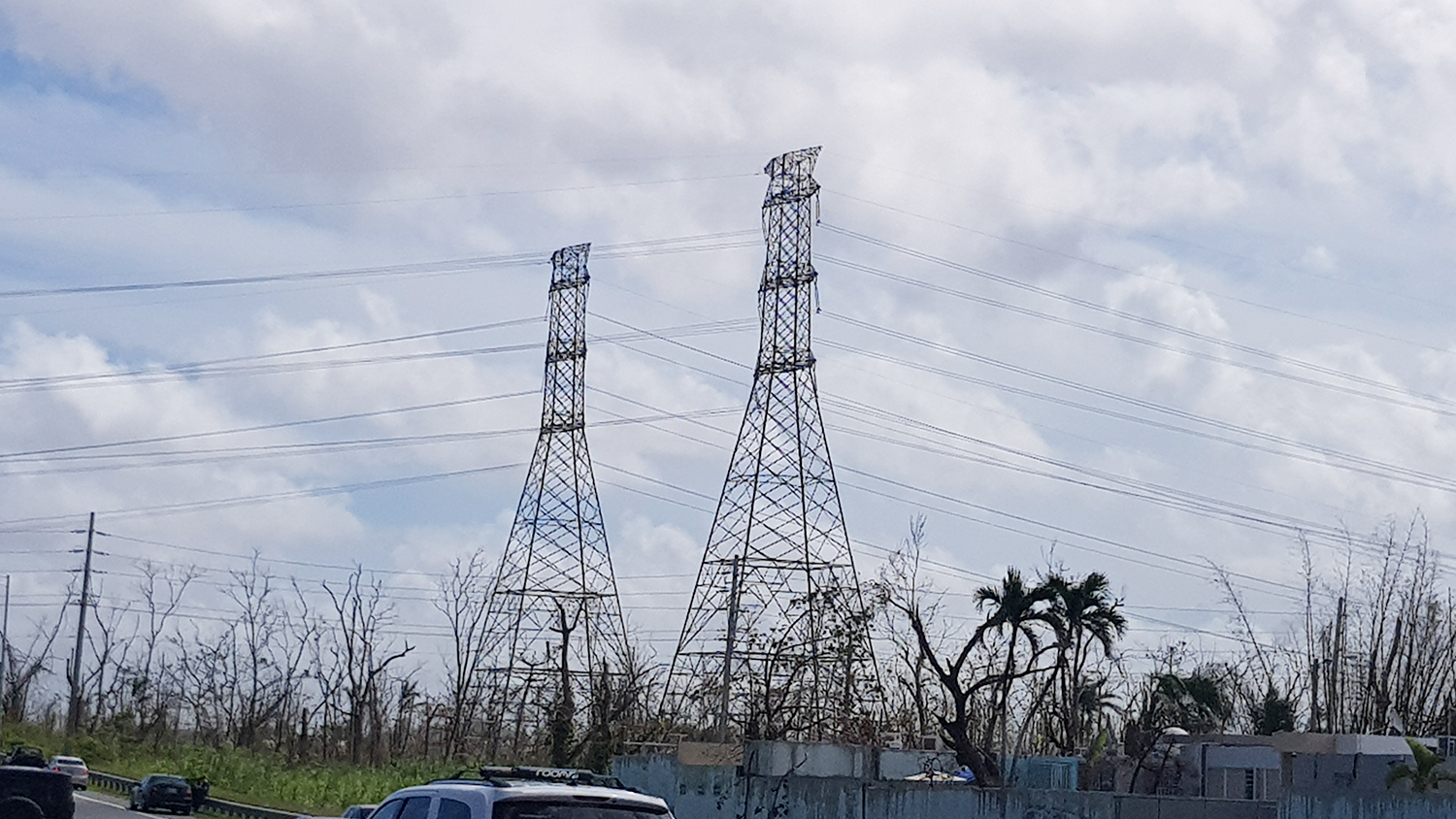
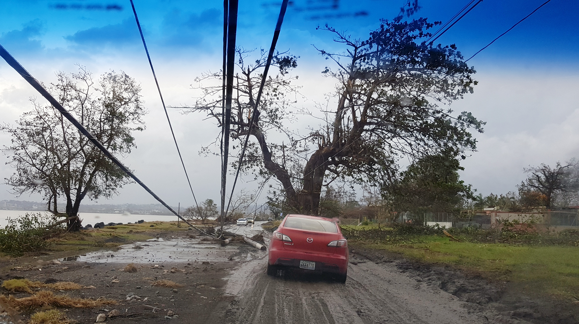
“Puerto Rico depends mainly on oil or carbon-burning plants. The centralized public energy supply system totally collapsed during and after María, with outages in some locations lasting for more than nine months. More than 50,000 power poles and associated devices needed to be reinstalled just to replace those totally damaged, leaving others in a weakened state during initial recovery.
Although Puerto Rico looks like an ideal demonstration site for a renewable energy grid, the initial investment currently surpasses our possibilities. Although a few residents had their own generators, the access to new generators and fuel ran out quickly, leaving the community without alternatives. Limited redundant power sources were available for public utility plants such as water or sewer pumping stations, which ultimately allowed sewer overflows.
The power grid in Puerto Rico is weak and vulnerable due to age and lack of maintenance and upgrades to more efficient methods. The island needs to provide redundant power generators, move into independent renewable energy through localized micro-grids and consider other alternative, sustainable and resilient energy sources.
Power is necessary to provide medical and the other critical, life-saving services that were jeopardized during the storm. The reduction of any level of direct or post-event, storm-related deaths should be the first priority of any future preparedness plan.”
4. The same goes for water and wastewater infrastructure:
“Potable water for drinking and washing are very high-priority during and after a disaster. With María, alternate water sources, water and sewage treatment plants, water distribution networks and sewers were exposed to coastal, riverine and urban flooding and backflow. Landslides broke storm and sanitary sewers and water supply networks. The lack of redundant power generators at treatment plants and pumping stations allowed sewage to overflow and exposed the water supply to multiple sources of contaminants. Pressurized water distribution networks can be short-circuited, so surrounding contaminated water could infiltrate into the potable water pipe network. Sufficient potable water, water cisterns and on household water treatment and safe storage are priorities for a resilient response and recovery after a hurricane.
It was common to improvise potable water sources or water treatments without knowing the chemical or biological implications of being exposed to unsafe water. Adding excessive doses of chlorine or other chemical treatments to water may be more dangerous in some instances than not treating it at all. Collecting rainwater became a great source of raw water, but the community must be aware of the appropriate processes to be able to safely treat and use that water. Dr Ingrid Padilla, a faculty in Environmental Engineering at the Civil Engineering Department has extensively studied the lingering health effects of Hurricane María.
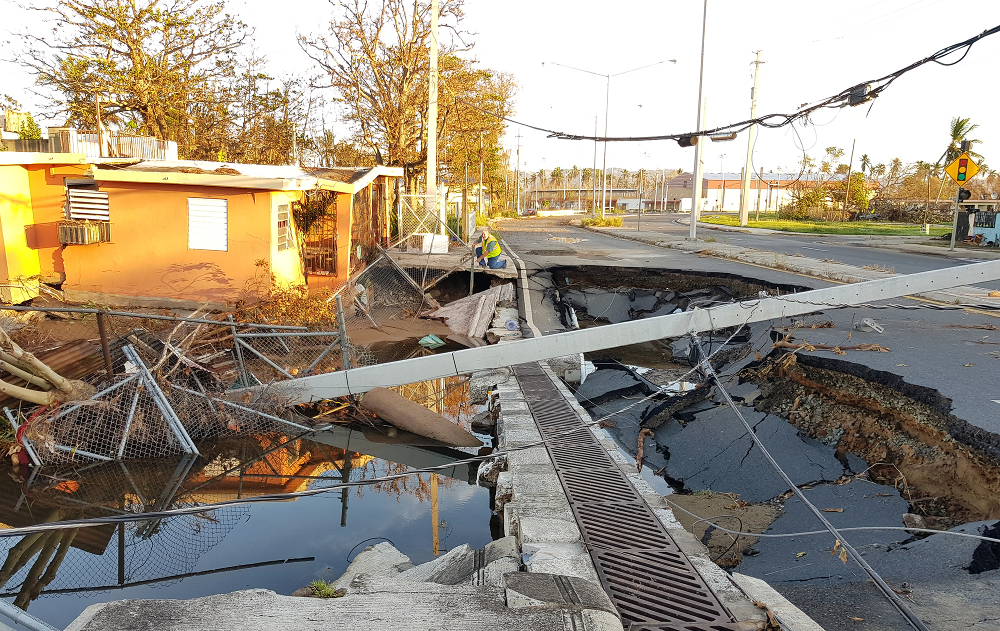
5. Drainage in flood-prone areas needs improvement:
“More than half a million Puerto Ricans live in flood-prone coastal and riverine zones based on official FEMA National Flood Insurance Program (NFIP) maps. There are many urban, flood-prone areas which are not included on those maps – some estimates show the total number of people living in flood zones being substantially higher. Although Puerto Rico is under NFIP coverage, most of these communities were located there before the program began or were illegally located there after the program began in Puerto Rico.
Flooding during the hurricanes happened within and outside delineated NFIP zones. After Hurricane María, more than 250,000 structures were estimated to be located within the flood-prone zones, an estimate of 50,000 more than those within the Flood Insurance Rate Maps (FIRM) limits. Since then, new Advisory Flood Elevation Maps were developed and adopted as regulatory flood maps by the Puerto Rico Planning Board based on the actual flooded zones after María, while new flood-prone areas were identified at places such as the Levitt Town Housing complex at Toa Baja. FIRM maps will go through the approval process based on the new flood elevation data after María.
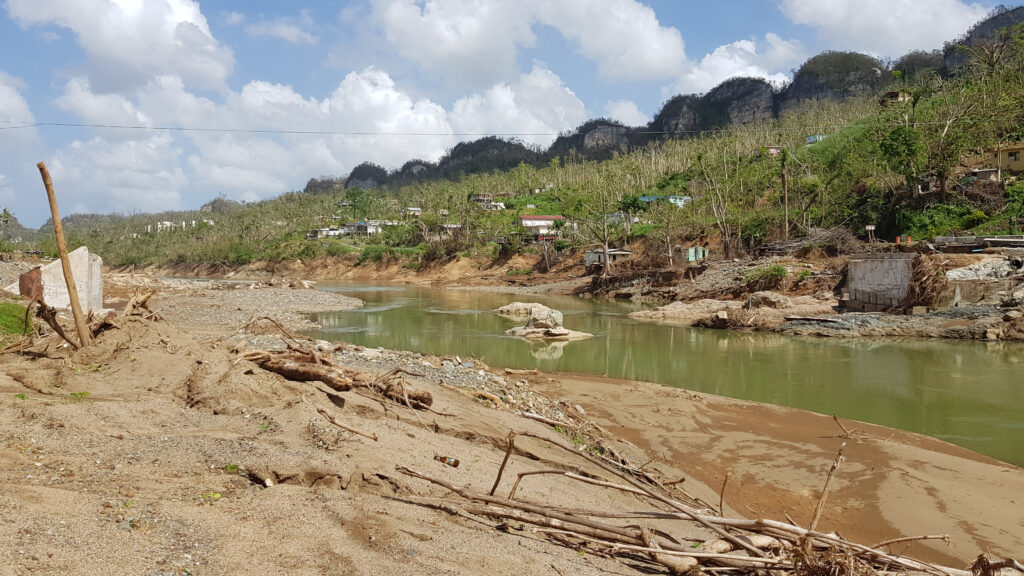
Excessive runoff caused floods everywhere and many shallow landslides, extensive superficial erosion and mud flows; excessive sediment flowed into lakes and the sea. Lakes were compromised, with a near-failure at the Guajataca dam. Extensive coastal erosion could be seen along the nearly 800 miles of coastlines; 60 percent of beaches showed moderate to severe erosion. About 24 percent of the coastline has been rebuilt.
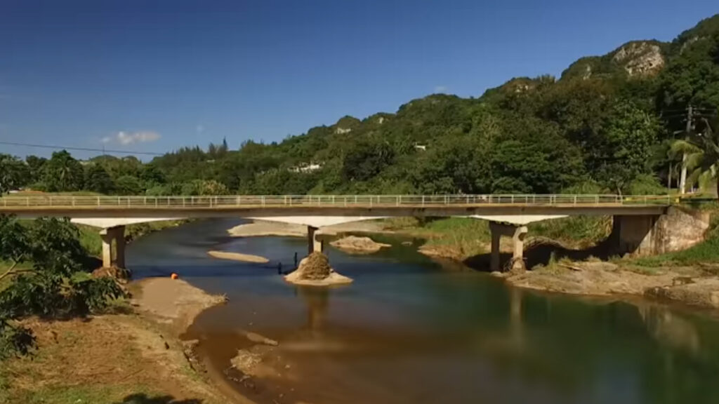
The debris transported by rivers clogged bridges and culverts, leading to scouring, overtopping and even failure and destruction of many drainage structures. Of more than 200 affected bridges inspected by the Transportation and Highway Authority, more than 60 were severely damaged or washed out. Although our bridge inventory is under the Federal Highway Administration Bridge Inspection Program, our experience will require revisiting the evaluation of those and other bridges. We need to update the Dam Safety Program with the new data left by Irma and María.”
6. The island setting is unique:
“Being an island presents different and more complicated challenges to be prepared, respond, recover and become more resilient. There are 2.3 million people (61 percent of the island’s population) at 44 coastal municipalities. Recovery assistance can only arrive through airports and seaports; on the mainland, goods and services could delivered through ground transportation. Eleven airports and 12 seaports at coastal zones have a limited capacity, and that supply is very slow and not continuous. The vulnerability of airports and seaports to natural hazards like hurricanes, storm surges and tsunamis limits the robustness of this infrastructure to allow the necessary support. It also limits the ability to evacuate out of the hazardous zones through ports.”
7. The state of the Island’s infrastructure is unique to the United States:
“Puerto Rico’s infrastructure has been installed over the past 500 years. Most of the modern U.S. infrastructure was installed during past century. Issues in Puerto Rico include aging, lack of a maintenance program, and outdated engineering codes, regulations and guidelines when older infrastructure was built. Add the extreme environmental and ambient stresses like corrosion, high humidity, high temperatures, extreme winds, exposure to earthquakes, and limited funding to do better, and the poor response of our infrastructure to these hurricanes makes more sense. Along the coast, there are:
- Seven power plant systems (five public, two private)
- 125 miles of potable waterand more than 160 miles of sanitary sewer infrastructure
- 28 wastewater treatment plants
- 81 industrial parks
- A significant fraction of the island’s 17,000 miles of primary roads.
—————————————-
Prof. López also mentioned the following lessons:
8. Most residences and buildings designed to current code resisted the winds:

“The current building code in Puerto Rico is based on the International Building Code of 2009, which relies on the ASCE7-05 standard for calculation of wind loads. Although there are newer versions of both, the recently designed structures were able to resist the strong winds caused by María without failure. Most of the problems in these structures was related to water entering the structure through windows and doors.”
9. Residences not designed according to code had structural problems:
“There was a large number of residences and other structures that failed because of the wind and these were already very susceptible to wind damage. Most failures were due to metal roof uplift and failure of lightweight timber housing constructed without proper connectors or with small structural elements. In general these structures did not comply with the current code. Many were in rural areas which building inspectors do not reach, but some were older structures inside cities and towns. There is much to be gained by insuring that these new structures comply with recent design codes.
María has created a new sense of urgency in terms of how to be prepared and how to respond to hurricane warnings.
10. There are many structures constructed in zones prone to landslides:
“This is a major problem because there is no easy solution. The large number of landslides (U.S. Geological Survey estimates more than 40,000), caused mostly by the heavy rains in the mountain zone, left many houses damaged or in danger of further damage in a future heavy rain. To complicate the issue, Puerto Rico is in a high earthquake-risk zone and the latest strong earthquake occurred 100 years ago, when most of the current construction was not built. Because some of the soil failures in landslides were so massive, the only solution appears to be moving to safer areas.”