
About 43 percent of the nation’s population lives in areas protected by levees, but rising sea levels and land subsidence increasingly threaten these structures.
That’s why Dr. Victoria Bennett of Rensselaer Polytechnic Institute (RPI) is working to empower levee officials to use satellite imagery and GPS sensors to more quickly and cost-effectively assess the health of levee systems and prioritize levee maintenance.

Bennett is the Principal Investigator for the Coastal Resilience Center of Excellence (CRC) project “Establishment of Remote-Sensing Based Monitoring Program for Performance Limit State Assessment of the Sacramento Delta,” which brings together researchers from across the country to validate remote-sensing measurements from a section of the Sherman Island levee in California’s Sacramento Delta.
While Bennett conducts field work in California and manages the monitoring system at RPI in New York, Dr. Mo Gabr and Dr. Brina Montoya at North Carolina State University are using the collected data to develop the computer model in PLAXIS-2D. Other research partners include the National Aeronautic and Space Administration (NASA) Jet Propulsion Laboratory in California and the U.S. Army Corps of Engineers’ Engineer Research and Development Center in Mississippi.
“This project brings together the necessary combination of numerical modelers, experimentalists, remote sensing experts and end users,” Dr. Bennett said. “We can do much more together than any one researcher could do on their own. While it is sometimes preferable to meet face-to-face, a lot can be accomplished remotely.”
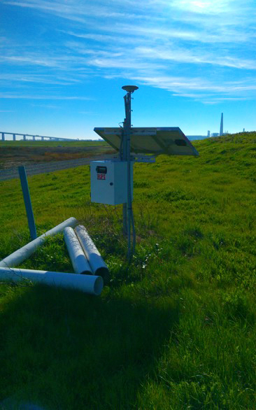
The project involves attaching three advanced, standalone GPS stations to a section of the Sherman Island levee and using the data from these in situ sensors to validate measurements from airborne and satellite radar images of the levee over time. These validated measurements are used to develop a numerical model to help assess the levee’s structural stability from increased stress from the water load pushing against it and variable rates of peat layer decomposition underlying the California Delta area.
“The model provides data that allow the end user to classify the levee within the context of ‘acceptable’ versus ‘need improvement’ performance limit states,” Dr. Gabr said.
A change in process
The use of this technology is a sharp departure from the visual inspections often used to assess levees, Dr. Bennett said.
“When regular visual inspections are conducted by trained personnel, this is an effective way of recording and reacting to necessary levee maintenance if the issue is visible to the human eye,” she said. “A remote sensing-based approach coupled with modeling will allow us to detect much smaller deformations, hopefully enabling a shift from reactive to proactive maintenance.”
To date, project partners have discovered that amorphous peat composition led to lower levee displacement than fibrous peat, and that high water levels in the short term caused less displacement in view of the magnitude of the compression of the levee’s peat layer over time.
The computer model for assessing the deformation response of the levee at Sherman Island has been built within PLAXIS-2D, a geotechnical engineering tool that allows two-dimensional analysis of stability, including the effect of loading from multiple storms and long-term deformation effects.
End users for the project include the California Department of Water Resources, the California Governor’s Office of Emergency Services and the California Reclamation District #341.
Levees in the Sacramento Delta were chosen because of their high risk of failure and their location in an area of high seismic activity, Bennett said. A preliminary risk assessment showed a 40 percent chance that least 30 islands within the Delta area would be flooded by simultaneous levee failures in a major earthquake in the next 25 years. Failure of the system could jeopardize the individuals living in the area, roughly $500 million in agriculture crops and the freshwater system for Southern California.
Once remote sensing measurements are validated and researchers gain confidence with their technique, the project’s results could help improve levee systems beyond the Sacramento Delta, Dr. Bennett said.
Failing grades
The American Society of Civil Engineers 2013 Report Card for America’s Infrastructure gives the condition of the country’s dams a grade of D and levees a grade of D-, which is unchanged since the 2009 report. The situation is further complicated by the massive amount of flood-control infrastructure to inspect.
Assessing the health, predicting the failure of and implementing countermeasures are challenging tasks for any civil infrastructure because they suffer long-term wear from the environment, Dr. Bennett said. To efficiently maintain this infrastructure, managing engineers should have access to fully automated programs to continuously monitor, assess the health and adaptively upgrade these systems.
“An accurate monitoring and health assessment of a sprawling system of levees, such as those protecting New Orleans or along the Mississippi River, using only traditional sensors and sensing techniques is expensive and technically challenging,” she said. “We propose deploying cost-effective tools and techniques that build on existing remote sensing assets to monitor levee health for long-term failure mitigation.”
Potential follow-on work includes developing a user interface for the modeling that results from current data collection; adapting parameters of the model based on observations of peat layer decomposition; and linking results to general resilience guidelines for water, ecological and economic resources of the area surrounding levees.