
Researchers at Louisiana State University and thousands of residents in south Louisiana are still feeling the effects of historic rain event that hit the area in August 2016. The event brought more than two feet of rain in some areas during the month, with 11 river gauges in the state reporting record flood levels.

A project led by Dr. Robert Twilley of Louisiana State University hopes to help communities adapt planning and response to minimize the impact of future storms that could leave similar damage. Dr. Twilley’s project, “Integrated Approaches to Creating Community Resilience Designs in a Changing Climate,” is aimed at improving resilience in two specific ways; focusing emergency response to better protect vulnerable infrastructure and people, and reducing repetitive loss by giving community planners accurate estimates of infrastructure vulnerability of events that may happen in the future.
His team includes faculty at other Louisiana State University institutions: Director Jeff Carney and Assistant Research Professor Traci Birch of the Coastal Sustainability Studio, Brant Mitchell, Director of the Stephenson Disaster Management Institute; and Carola Kaiser of the Center for Computation and Technology. This combination provides end users with experts from the fields of disaster research and response; coastal hazards modeling; planning and design; and outreach from the Louisiana Sea Grant College program (where Dr. Twilley is executive director).
“Communities want clear guidance on what infrastructure and people could be threatened by a tropical storm and/or major rainfall events,” Dr. Twilley said. “Our project integrates coastal modeling tools into community design and planning, and couples it with outreach efforts to emergency managers and land use planners to obtain community-level data about vulnerable infrastructure.”
Researchers will develop pre- and post-disaster planning and adaptation tools for coastal communities to improve resilience. These efforts will enable vulnerable communities to plan, react and recover more quickly and effectively in areas facing repetitive disturbances. They have been incorporating consequence modeling – which creates realistic scenarios for planning before a disaster – into results from CERA, the mapping interface that displays results of the ADCIRC storm surge model to show how flood risks will impact people, industry and coastal infrastructure. Using that tool, project participants will inform community planners on impacts, helping them reduce repetitive loss by updating land use and redevelopment guidelines following flood events.
With trusted sources doing community outreach to emergency managers and planners, researchers hope to mitigate future risks through current action. Building on the strength of each research and outreach center in the partnership, they aim to reach vulnerable populations with flood prediction, protection and response materials.
The resulting CERA-Consequence Model will show how flood risk (both from storms and sea-level rise) will impact people, industry and infrastructure. Utilizing this data, they plan to provide:
- Planning tools that visualize risks to include hurricane-force winds, storm surge and inland flooding along with vulnerable populations based on socio-economic status
- Modeling and visualization tools to communicate flood risks during a storm by identifying vulnerable populations and structures that are susceptible to storm surge
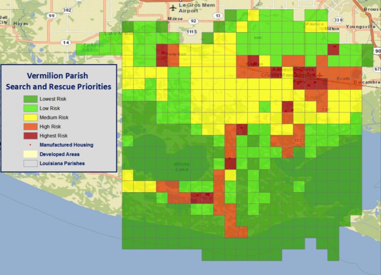
- Post-landfall search and rescue grid system with prioritization based on socio-economic vulnerabilities
- Methodology for helping community planning departments and recovery planning teams effectively utilize and implement changes to their built environment through effective resilience-based planning.
Dealing with the Consequences
The CERA-Consequence Model has so far been used to capture the diversity of coastal infrastructure and assets in the Mississippi River Deltaic Plain (MRDP). Researchers have conducted preliminary analysis of hurricane impact scenarios to capture the diversity of recovery and adaptation needs in the MRDP to determine what data can be used in the model. They will take this data to build an automated model in the CERA mapping platform to interpret ADCIRC Surge Guidance System (ASGS) outputs and analyze community-level impacts of expected storm surge in a new website called “CERA-Planning.”
In the first year of the project, Dr. Twilley and the project team focused on outreach to ensure local, state and federal planners – along with emergency managers – were aware of the project and its potential to influence decision-making and planning processes. Those reached include the State of Louisiana, American Planning Association and the Louisiana Emergency Preparedness Association, as well as many local and regional emergency management groups, among others.
Proposed modeling products were evaluated at an annual focus group workshop to engage end users directly in the development process. Feedback is now being used to develop integrated approaches on the new CERA-Planning website, for university-based design studio courses and design/outreach entities working in target communities.
Building the database
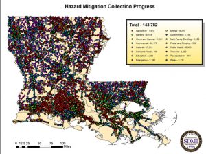
Researchers also formed a focus group of emergency managers and planners to determine sectors not involved in the data-collection process. Already, the data stream is expected to be large, comprising more than 140,000 data points on infrastructure from the State of Louisiana that serves as the basis for this model. The scope for the project includes possible expansion to communities across the United States, bringing in additional users such as the National Communications Center (NCC). The NCC is responsible for providing situational awareness for all communications infrastructure during tropical cyclones and U.S. Coast Guard–Sector New Orleans.
Other additions could include adoption of parcel data and building footprints in the consequence model. Critical infrastructure such as water utilities and sewer treatment plants will be included, as storm surge could disrupt their operations and severely impact a community’s ability to recover.
The original data source for the 140,000 data points on infrastructure across the State was a joint project between SDMI and GOHSEP funded by FEMA. This data set established the original source of information for the consequence model in this CRC project; initial focus groups worked to prioritize information needed to indicate infrastructure vulnerabilities.
“This information will also be used to prioritize information needed to identify infrastructure vulnerabilities in planning to reduce competitive losses,” Dr. Twilley said.