
Coastal modelers and decision-makers gathered April 9-13, 2018, to learn, discuss, plan and build capacity for ADCIRC, a tool that provides decision support for hazards like storm inundation during tropical and extratropical cyclones.
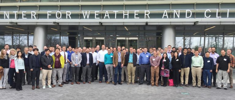
The 22nd ADCIRC Week, a gathering of professionals, academics, students and officials, was hosted by the National Oceanic and Atmospheric Administration (NOAA) National Center for Weather and Climate Prediction in College Park, Md. The Week included the ADCIRC Boot Camp training event from April 9-11 and the ADCIRC Users Group Meeting from April 12-13.
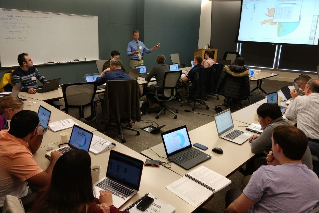
The three-day ADCIRC Boot Camp, organized by Dr. Jason Fleming, Principal Consultant at Seahorse Coastal Consulting and a co-PI on a Coastal Resilience Center of Excellence (CRC) project, expanded this year from two to four simultaneous tracks – from newcomers to high-level decision-makers who use the results. Student attendance at the Boot Camp was sponsored by the CRC to support workforce development.
Several CRC researchers involved in ongoing projects are continuing to improve ADCIRC, by adding new model inputs, such as precipitation, and decreasing the computer power needed to run simulations.
“I think ADCIRC Week continues to grow because it is a great opportunity to make those personal connections that are so key to success, even in our fast-paced industry,” Dr. Fleming said. “Researchers and developers sit down together in person to discuss code development, the newcomers learn from the experts, and our community leaders give perspective and direction. We all look forward to the Users Group Meeting and come away with new information and fresh enthusiasm.”
Researchers share applications of software
This year’s Boot Camp included a high-level “ADCIRC for Decision Makers” panel discussion on Wednesday, April 11, for state and federal government stakeholders, including FEMA and the U.S. Coast Guard. The forum connected university researchers to decision-makers who use ADCIRC model guidance for flood fighting, search-and-rescue and emergency asset prepositioning. The researchers described the current state of ADCIRC model guidance along with the new innovations they have under development. Decision-makers provided ADCIRC success stories from experiences during hurricanes Isaac, Harvey and Maria, as well as descriptions of the expanded capabilities they would like to have going forward.
The 2018 ADCIRC Users Group Meeting gave coastal modelers and ADCIRC developers the chance to show off the latest new features and engage in interactive discussions to advance the state of the art in ADCIRC modeling.
The two-day Users Group Meeting kicked off with a keynote address from Hendrik Tolman, Senior Advisor for Advanced Modeling Systems at NOAA. Dr. Tolman provided a broad historical perspective on the development of practical operational modelling systems and the NOAA vision for the future of model decision support.
His keynote was followed by plenary talks from NOAA researchers that produce critical infrastructure for ADCIRC decision support, including wave coupling capabilities, ADCIRC model guidance for the National Hurricane Center and accurate ground elevation references for calculating inundation. Their talks were followed by researchers and private-sector practitioners presenting their development and use ADCIRC for a diverse range of applications.
The Users Group Meeting closed on April 13 with four tracks of special-interest meetings including developer tutorials; “birds-of-a-feather” meetings (for MATLAB software and programming languages Python and Perl); GIS integration for ADCIRC; and a career fair.
“[The meeting] was everything that I needed at this point in my research to equip myself with the recent advancements in ADCIRC and its applications,” Arslaan Khalid, Ph.D student at George Mason University, said. “It was a great to meet all those big personalities in the field of storm surge.”
ADCIRC Man, Woman of the Year named
As an annual part of ADCIRC Week, the community of users voted for ADCIRC Man and Woman of the Year for individuals’ visibility on the ADCIRC online community, leadership, outreach and capacity-building contributions beyond their official job descriptions.
The 2018 ADCIRC Community Woman of the Year is Kendra Dresback, Research Assistant Professor at the University of Oklahoma, and the 2018 ADCIRC Community Man of the Year is Zach Cobell, Surface Water Hydrologist at ARCADIS.
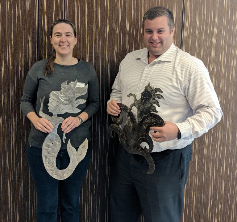
“Over the past nine years, Cobell has consistently added features to the ADCIRC code, developing tools and methodologies for pre- and post-processing data,” according to nominations. “He develops solutions to complex problems, and so often is one of the first to respond on the listserv with answers and good ideas. He has incredible, in-depth knowledge of the code and spends an enormous amount of his personal time supporting it.”
“Kendra Dresback has made a wide variety of contributions to the ADCIRC Community, including vectorization of the core of the software to improve performance, enhancement of the 3D baroclinic features, and developing and supporting hydrological model coupling in North Carolina,” according to nominations. “She has also mentored many new students over the years and volunteered to co-teach the first ever ADCIRC 3D session at the ADCIRC Boot Camp in 2018.”
Other finalists for the award were William Pringle, Postdoctoral Research Associate at the University of Notre Dame, and Crystal Fulcher, Research Technician at UNC-Chapel Hill’s Institute of Marine Sciences.
“Zach and Kendra are pillars of the community, so it was gratifying to see them recognized for these awards,” CRC Lead PI and ADCIRC co-developer Dr. Rick Luettich said. “Zach has dramatically improved our development processes while Kendra’s algorithmic contributions over the years produced new capabilities that we rely on every day. We are so grateful to have them in our community.”
CERA updates for 2018
Attendees learned about the updated Coastal Emergency Risks Assessment (CERA) web mapper, which is used to display results from ADCIRC model runs. For the 2018 hurricane season, CERA has multiple formats – for a general audience and for frequent users. While basic ADCIRC model run results will be displayed in the public version, the login-enabled CERA-PRO website allows users to see the full range of data for each model run, see more variations on storm tracks and grids and provide higher performance and downloads of data. The CERA-PRO site also allows users to pre-set elements of their map, enable geolocation searches and a 24/7 contact tool during active tropical storms.
About ADCIRC and CERA
The ADCIRC Storm Surge Guidance System combines information on tides, river flows, wind, atmospheric pressure and surface waves to predict the response of the coastal ocean, including when, where and to what extent storm surge and flooding will impact a coastal community, often with greater precision than other available models. Results are made publicly available on the CERA website.
Results generated by ADCIRC are used by multiple federal and state agencies to help predict flooding associated with storm surge. The U.S. Army Corps of Engineers, the National Oceanic and Atmospheric Administration, the U.S. Coast Guard, the Federal Emergency Management Agency and the North Carolina Department of Emergency Management are among the agencies that factor ADCIRC modeling into their operations. At the local level, results are shared with coastal emergency managers to assist with decision making including road closings, evacuations and search and rescue operations.
For more information on ADCIRC and CERA, watch this video from the CRC and visit adcirc.org.