
Researchers at the Coastal Resilience Center of Excellence (CRC) have been working with hurricane forecasters and emergency response officials to track Hurricane Matthew as it made its way through the Caribbean and up Florida to the Carolinas earlier this month. Using technology and tools being developed and improved through Center projects, they will continue to aid in the recovery process and in making improvements to track storm impacts in the future.
Several CRC projects focus on the dynamics of coastal storms, while others focus on the impacts to coastal infrastructure. Another set of projects focus on long-term planning for disasters and tracking of storm recovery, among other community resiliency factors.
Hurricane Matthew has been attributed to more than 1,000 deaths in Haiti when it came ashore as Category 4 storm. Though it slowed as it approached Florida, Georgia and the Carolinas, the storm has caused more than 30 deaths in the United States, with an initial loss estimate of close to $5 billion.
Predicting the storm surge through partnerships
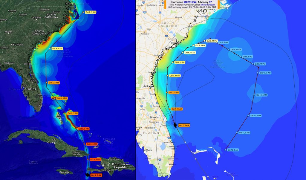
Hurricane Matthew’s westward direction changed to a northward path on Oct. 1-2. A team of Coastal Resilience Center researchers, including partners from the University of North Carolina at Chapel Hill (UNC-CH), Louisiana State University (LSU), North Carolina State University (NCSU) and Seahorse Coastal Consulting performed storm surge and wave forecasts using the ADCIRC modeling system as the storm tracked through the Caribbean and up the southeast coast of the United States.
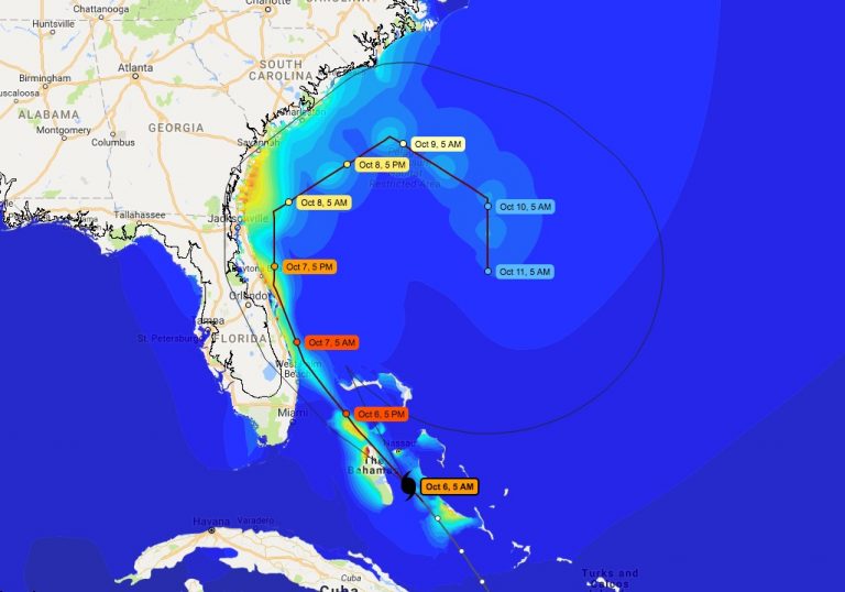
ADCIRC results are displayed on the Coastal Emergency Risks Assessment (CERA) website, which was developed and is managed by LSU. This website overlays ADCIRC system results on maps of the Atlantic coast and Gulf of Mexico.
The development and operation of both the ADCIRC system and the CERA website have been partially funded by the Department of Homeland Security.
The results are shared with several groups of professionals, including local emergency management groups, to help local leaders make informed decisions related to road closings, evacuations and search and rescue. The National Oceanic and Atmospheric Administration (NOAA), U.S. Coast Guard, U.S. Army Corps of Engineers and Federal Emergency Management Agency (FEMA) are among the agencies that factor ADCIRC modeling into their operations.
ADCIRC was developed by CRC Principal Investigator and UNC-Chapel Hill Professor Dr. Rick Luettich, along with Dr. Joannes Westerink at the University of Notre Dame and Dr. Clint Dawson at the University of Texas. Four CRC projects are investigating improvements to the model to make it faster and more detailed.
During Hurricane Matthew, the computing power to run several ADCIRC simulations every six hours was provide by the UNC-CH Renaissance Computing Institute (RENCI), a partnership with, Duke University and NCSU, and at the Center for Computation and Technology (CCT) at LSU.
Interest was high and widespread during Hurricane Matthew’s path up the East Coast. The CERA website was accessed from 45 U.S. states, with the highest concentration in North Carolina, and the next highest along the East Coast and Gulf states. Website traffic between Oct. 2-10 peaked at close to 2,000 unique hits per day, a roughly tenfold increase in the traffic generated during Tropical Storm Hermine in late August and early September.
State of NC utilizes ADCIRC
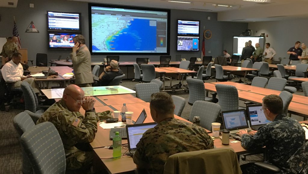
Dr. Casey Dietrich of NCSU, whose CRC project focuses on improving the speed of ADCIRC modeling, visited the North Carolina Emergency Management (NCEM) State Emergency Operations Center to see NCEM’s operation and workflow during storm response. Dietrich said emergency managers were excited about the data provided by ADCIRC predictions.
“They are using both the CERA site and the shapefiles we are generating,” Dietrich said. “The shapefiles are being combined manually with other datasets to determine the potential flood damages, in terms of both number and cost of buildings and infrastructure.”
Dietrich said that ADCIRC predictions have compared favorably to post-storm high-water marks and U.S. Geological Survey measurements of storm surge.
“Their comparisons after Hermine showed matches within a foot to the peak water levels,” Dietrich said. “They described ADCIRC as their eyes on the coast.”
Dietrich’s work with ADCIRC to provide more accurate storm surge estimates for North Carolina is also partially funded by the North Carolina Sea Grant and the National Consortium for Data Science.
Tracking damage and recovery

Dr. Don Resio of the University of North Florida, whose CRC project incorporates precipitation into hazards modeling, is studying storm surge and flooding impacts on the Atlantic Coast of Florida following Hurricane Matthew’s impact. He will be part of a team taking aerial photography and gathering in-situ on-ground data on high-water marks and damages, in coastal areas of St. Augustine and Jacksonville.

Dr. Phil Berke of Texas A&M University, whose current CRC project focuses on the coordination of local plans to address hazards, will examine the effects of local implementation efforts of hazard mitigation programs after Hurricane Matthew. The sample of communities to be studied will be drawn a larger prior CRC-supported study on hazard mitigation planning in coastal areas of Florida, Georgia and North Carolina. The sample will cover those communities that sustained impacts from Hurricane Mathew. The previously collected data provides a unique opportunity to assess the effectiveness of plans designed to reduce vulnerability. Berke will be working with Dr. Ward Lyles of the University of Kansas, who completed his doctorate at UNC-CH with support by the prior CRC project.
Media coverage
Dr. Luettich, who is also director of UNC-CH’s Institute of Marine Sciences, issued regular updates from ADCIRC runs on Twitter, and gave media interviews on storm surge with local and national outlets, including The Washington Post, HPC Wire and WNYC.
CRC Director Dr. Gavin Smith, who worked for state emergency management agencies in disaster recovery post-Hurricane Katrina (2005) in Mississippi and post-hurricanes Fran (1996) and Floyd (1999) in North Carolina, said that North Carolina faces a recovery situation similar to Floyd. Downstream communities in the eastern part of the state will continue to deal with flooding from the large amounts of rainfall from Matthew, which dumped as much as 16 inches in areas south of Raleigh. Dr. Smith said he hopes to involve planning students from his classes at UNC-CH in the recovery process in the eastern part of the state.
Additional media coverage can be found at coastalresiliencecenter.unc.edu/crc-media/in-the-news.