
As the weekend of August 21, 2021 drew near, it became increasingly evident that Tropical Storm Henri would not only impact Southern New England, but could become a hurricane before making landfall. This situation gave researchers at the University of Rhode Island (URI) a chance to test out the real-time storm modeling capabilities of the Rhode Island Coastal Hazards, Analysis, and Modeling Prediction (RICHAMP) system, a Department of Homeland Security-supported project which advances storm model capabilities and develops a near real-time hazard and impact prediction system for hurricanes and nor’easters in Southern New England. The project is developed through the Coastal Resilience Center and makes use of the ADCIRC Prediction System™.
RICHAMP runs on existing ArcGIS systems typically in use at Emergency Operation Centers (EOCs) around the country. It integrates end-user knowledge and concerns with hazard predictions from the ADCIRC Prediction SystemTM to provide predictions of cascading consequences of extreme weather (i.e., surge, wind, flooding, waves) impacting critical infrastructure (e.g., wastewater treatment facilities, sewer systems, airports, and seaports). The developers’ approach addresses the challenges inherent in collection and dissemination of infrastructure data by partnering with critical lifeline sector leads and leveraging existing technology in use at EOCs.
The Coastal Resilience Center is a Department of Homeland Security Center of Excellence and part of a network of universities who support the Department of Homeland Security (DHS) Science and Technology Directorate’s Office of University Programs. The Center is a consortium of universities, private companies, and government agencies, led by the University of North Carolina at Chapel Hill (UNC), focused on applied research, education, and outreach addressing threats to coastal communities due to natural hazards.
As Henri was first forecast to move toward New England, a Coastal Resilience Center modeling team, including Dr. Brian Blanton (UNC Renaissance Computing Institute – RENCI), Dr. Isaac Ginis (URI School of Oceanography), Dr. Rick Luettich (UNC Institute of Marine Sciences), and Dr. Jason Fleming (Seahorse Coastal Consulting) coalesced to produce hazard forecast updates every six hours using RENCI’s Hatteras high-performance computing system. Dr. Austin Becker (URI Department of Marine Affairs) and his team worked on collecting subject matter experts’ concerns and creating a website portal to visualize and disseminate the information to a select group of emergency management end-users.
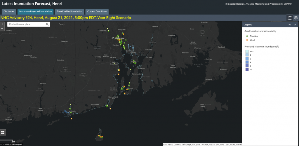
Above: an example of the RICHAMP pilot test visualization during TS Henri showing the inundation forecast for the Southern New England coast.
During the testing period, all eyes closely monitored the path and development of Henri. During each six-hour forecast cycle, the team worked toward developing multiple storm scenarios that might bracket the expected conditions. As an output product, Dr. Becker and his team provided the selected end-users with a web URL link to an online viewer that displayed the forecasted inundation levels for Rhode Island. With each subsequent update, the team provided information on how the forecast was produced.
“The Department of Homeland Security funding allowed us to significantly enhance the spatial resolution of the ADCIRC mesh and better resolve areas of interest in Southern New England,” said Dr. Ginis. “The landfall of Tropical Storm Henri in Rhode Island provided a unique opportunity to inform local emergency managers and decision-makers in real-time about new modeling capabilities for predicting coastal flooding and impacts from extreme weather conditions.”
According to Dr. Becker, “Henri provided a fantastic opportunity to test out the products that have been in development in partnership with the Rhode Island Emergency Management Agency and other key partners. The results show the incredible potential this tool has to aid in emergency response.”
Dr. Becker emphasized that this was an experimental pilot test run, and that the data produced was not meant for decision-making. The information supplemented regular situation reports on Hurricane Henri that were provided by Dr. Luettich, lead principal investigator for the Coastal Resilience Center. Each report was shared with DHS over the weekend as they became available.
“For the past several years, we’ve been building out the ADCIRC Prediction System™ as a national coastal hazard forecasting system with primary support from the DHS Coastal Resilience Center,” says Dr. Luettich. “We were extremely pleased with how well it performed during Henri.”
During the experimental run of RICHAMP, Dr. Becker and his URI colleagues Chris Damon and Deb Crowley had to manually work through some steps of the process, which they plan to automate in the future.
This collaboration is a successful example of how a team of researchers, developers, and communicators can work together to implement new tools and processes to help coastal communities better prepare for and respond to adverse weather events.
For more information, visit:
RICHAMP – https://www.richamp.org/
Coastal Resilience Center – https://coastalresiliencecenter.unc.edu/
ADCIRC Prediction System – https://www.adcircprediction.org/
For comments or questions about this story, contact Matt Bryant, Coastal Resilience Center Communications Manager, at mbryant1@unc.edu.